Transformation changes the Hill
by Carl Vest
By most definitions South Hill can be classified as an urban area. Housing developments extend from the hillsides in the North to the Graham area on the South side. Given this concentration, it’s interesting to speculate about when it all started.
By focusing on the year 1900 a perspective can be developed. Records show that prior to the turn of the 20th Century the Hill had been surveyed only about 20 years earlier --- in the 1870s. Various archives have evidence that reveal formal road developments starting in the early 1890’s, primarily when the Ball-Wood Road was “laid-out” and recommended. Moreover, during this period the Hill gradually was populated by small-business farmers, most getting their land directly or indirectly from the railroad “grant” allocations --- after the lumber industry had logged-off nearly all the land.
After about 1900, however, the small farmer and logger was starting to be replaced by more dense concentrations of housing. Not dense by today’s standards, but compact by the ideals of the time. It started in the North, on the hillsides and plateau areas above the City of Puyallup --- called Puyallup Heights by many. In the beginning it was not an extensive or a fast change, but it was a movement nevertheless.
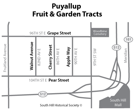
About 1908 one of the first of the large expansions was initiated, named the Puyallup Fruit and Garden Tracts. It straddled Sections four and five of Township 19, and bordered on the southern line of the Puyallup City limits. Later it would be part of the so-called Woodland area. The project consisted of 72 lots with a total area of one-half a Section, or 320 acres. Sixteen of the lots were two and one-half acres in size. The remainder measured five acres. While these sites seem large by today’s standards, at the time they were not considered unusual.
One of the interesting things about this neighborhood was the naming of its streets. In keeping with the overall theme several routes, for example, were named for fruits and vegetables. There was an East-West path across the northern top of the project, bordering the Puyallup City line, known as Grape Street. Across the southern edge a thoroughfare called Pear Street was built. North-South throughways were constructed between each of the equal areas of the project. Each went completely through the development. In keeping with the project theme, the most western route was called Walnut Avenue. The most eastern thoroughfare was called Apple Way. The center lane was called Cherry Street.
In modern terms those early streets have been renamed. Grape Street is now 96th Street East and Pear Street is 104th Street East. The North-South streets have also been redefined. Walnut Avenue is now 82nd Avenue, East; Cherry Street is 86th Avenue East; and, Apple Way is 90th Avenue East.
The original name, Puyallup Fruit and Garden Tracts, has virtually disappeared as a community indicator. It is more generally known as the Woodland area, if recognized at all.
Carl Vest, PhD, is a founding member and Research Director for the South Hill Historical Society.